This guide details the effects of simplifying a toposurface in Revit, using a sample piece of topography.
A toposurface was created from an imported DWG file, of around 1130′ x 970′ in size, and 78′ in total elevation change.
Procedure
The number of points, edges and polygons was recorded at various levels of simplification, and compared to the contours that Revit generated from the points, to see how much they changed fro their original positions. To figure out the number of edges and faces, the surface was imported into SketchUp as a DWG, where the numbers were reported under the model statistics.
The Results
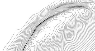
The accuracy of the simplification ranged from 1″ through 10′. When comparing the original contours to the Revit contours after the surface was simplified, the sweet spot seems to be between 6″ and 1′.

At 6″ to 9″, the contour lines closely follow the original lines, but above 1′, they start to become more angular.
| Simplification (Accuracy) | Points | Point Reduction | Edges | Edge Reduction | Polygons | Polygon Reduction |
|---|---|---|---|---|---|---|
| None | 16,823 | NA | 61,310 | NA | 33,507 | NA |
| 1″ | 11,273 | 33% | 48,644 | 21% | 22,406 | 33% |
| 2″ | 9,867 | 41% | 48,081 | 22% | 19,595 | 42% |
| 3″ | 9,086 | 46% | 46,295 | 24% | 18,033 | 46% |
| 6″ | 7,985 | 52% | 42,517 | 31% | 15,831 | 53% |
| 9″ | 7,508 | 55% | 40,424 | 34% | 14,877 | 56% |
| 1′ | 7,283 | 57% | 39,555 | 35% | 14,426 | 57% |
| 2′ | 7,065 | 58% | 37,949 | 38% | 13,990 | 58% |
| 5′ | 7,025 | 58% | 37,280 | 39% | 13,911 | 58% |
| 10′ | 7,027 | 58% | 37,281 | 39% | 13,913 | 58% |
A DWG file comparing all of the lines can be downloaded here.
You might also like